Watch Price
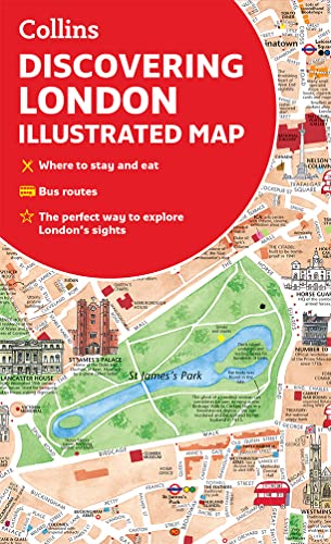
Discovering London Illustrated Map
A new edition of London’s most original map. This hand-watercoloured map contains individual paintings of all the main sites and landmarks, shop-by-shop street maps, theatres and cinemas, comprehensive travel information and index. This detailed map of Central London is at a scale of 1:8,250 (7.5 inches to 1 mile).
Coverage extends from Regent’s Park in the north to Battersea in the south, and from Kensington in the west to Tower Bridge in the east.
This attractive and fact-filled map would make a lovely souvenir for the visitor to London.
The map features:
• Railway stations, bus routes, London underground map, taxi ranks and car parks
• Shop-by-shop street maps for Oxford Street, Bond Street, Covent Garden, Portobello Road, King’s Road, Brompton Cross, Exmouth Market, Beauchamp Place, St. Christopher’s Place and South Molton Street, Knightsbridge, Jermyn Street and Kensington
• London’s theatres and cinemas
• Places to eat, internet cafés and good places for a picnic
• An inset map of the City of London
• Comprehensive index
• Historical and contemporary anecdotes
Coverage extends from Regent’s Park in the north to Battersea in the south, and from Kensington in the west to Tower Bridge in the east.
This attractive and fact-filled map would make a lovely souvenir for the visitor to London.
The map features:
• Railway stations, bus routes, London underground map, taxi ranks and car parks
• Shop-by-shop street maps for Oxford Street, Bond Street, Covent Garden, Portobello Road, King’s Road, Brompton Cross, Exmouth Market, Beauchamp Place, St. Christopher’s Place and South Molton Street, Knightsbridge, Jermyn Street and Kensington
• London’s theatres and cinemas
• Places to eat, internet cafés and good places for a picnic
• An inset map of the City of London
• Comprehensive index
• Historical and contemporary anecdotes
Detalles del producto
Editorial : Collins (17 marzo 2022)
Idioma : Inglés
Mapa : 2 páginas
ISBN-10 : 0008492611
ISBN-13 : 978-0008492618
Peso del producto : 78 g
Dimensiones : 11.3 x 0.76 x 20.5 cm
Clasificación en los más vendidos de Amazon: nº1 en Obras ilustradas de viaje
nº1 en Museos y museología
nº2 en Mapas y atlas
Opiniones de los clientes: 4,5
236 valoraciones
Editorial : Collins (17 marzo 2022)
Idioma : Inglés
Mapa : 2 páginas
ISBN-10 : 0008492611
ISBN-13 : 978-0008492618
Peso del producto : 78 g
Dimensiones : 11.3 x 0.76 x 20.5 cm
Clasificación en los más vendidos de Amazon: nº1 en Obras ilustradas de viaje
nº1 en Museos y museología
nº2 en Mapas y atlas
Opiniones de los clientes: 4,5
236 valoraciones
Amazon Price History
This is our record of Amazon price changes for Discovering London Illustrated Map (0008492611) since we began monitoring it.
| Price Type | Lowest Ever | Highest Ever | Current + | Average |
|---|---|---|---|---|
| Amazon | (Jul 08, 2026) | (Jul 08, 2026) | 0,00 € (Jul 08, 2026) |
0,00 €
Amazon Price
Jul 08, 2026 05:41 AM
Your Amazon Price Watches
We'll notify you when the price drops to your desired price.
Watch Price







Watch Price

Watch Price