Watch Price
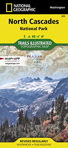
North Cascades National Park Map (National Geographic Trails Illustrated Map, 223)
• Waterproof • Tear-Resistant • Topographic Map
Explore the alpine forests, wild rivers, jagged peaks, and abundant glaciers of North Cascades National Park with National Geographic's Trails Illustrated map. Expertly researched and created in partnership with local land management agencies, this map features key points of interest including Baker Lake; Rockport State Park; Chelan and Ross Lake National Recreation Areas; Stephen Mather, Mount Baker, and Pasayten Wilderness Areas; Snoqualmie and Okanogan Wenatchee National Forests; and portions of the Sauk, Skagit, and Suiattle rivers.
With miles of clearly marked trails including the popular Pacific Crest and Pacific Northwest trails, this map can guide you off the beaten path and back again. Mileages between intersections are shown and the map base includes contour lines and elevations for summits. Helpful material about backcountry use, regulations, recreation activities, and agency contact information will assist you in making the most of your visit. Recreation features noted include alpine ski areas, rental cabins, lookout towers, campgrounds, interpretive trails, boat launches, fishing access, and more.
Every Trails Illustrated map is printed on "Backcountry Tough" waterproof, tear-resistant paper. A full UTM grid is printed on the map to aid with GPS navigation.
Product details
Publisher : National Geographic Maps; 2024th edition (January 1, 2024)
Language : English
Map : 2 pages
ISBN-10 : 1566953537
ISBN-13 : 978-1566953535
Item Weight : 3.21 ounces
Dimensions : 3.8 x 0.2 x 9 inches
Best Sellers Rank: #45,605 in Books (See Top 100 in Books)
#4 in Camping & Hiking Topographic Maps
#45 in Pacific West United States Travel Books
#61 in Hiking & Camping Excursion Guides (Books)
Customer Reviews: 4.8
281 ratings
Amazon Price History
This is our record of Amazon price changes for North Cascades National Park Map (National Geographic Trails Illustrated Map, 223) (1566953537) since we began monitoring it.
| Price Type | Lowest Ever | Highest Ever | Current + | Average |
|---|---|---|---|---|
| Amazon | (Jun 30, 2026) | (Jun 30, 2026) | 0,00 € (Jun 30, 2026) |
0,00 €
Amazon Price
Jun 30, 2026 03:50 AM
Your Amazon Price Watches
We'll notify you when the price drops to your desired price.
Watch Price
![Black Canyon of the Gunnison National Park [Curecanti National Recreation Area] (National Geographic Trails Illustrated Map) (National Geographic Trails Illustrated Map, 245)](https://m.media-amazon.com/images/I/71-3C27sm8L._SL500_.jpg)


![Grand Canyon East [Grand Canyon National Park] (National Geographic Trails Illustrated Map) (National Geographic Trails Illustrated Map, 262)](https://m.media-amazon.com/images/I/91J+I3Eq4SL._SL500_.jpg)
![Grand Canyon West [Grand Canyon National Park] (National Geographic Trails Illustrated Map) (National Geographic Trails Illustrated Map, 263)](https://m.media-amazon.com/images/I/81rN0wk1awL._SL500_.jpg)


![Shenandoah Day Hikes and National Park Map [Map Pack Bundle] (National Geographic Trails Illustrated Map)](https://m.media-amazon.com/images/I/81aKBzmxq9L._SL500_.jpg)
Watch Price
![Great Smoky Mountains Day Hikes and National Park Map [Map Pack Bundle] (National Geographic Trails Illustrated Map)](https://m.media-amazon.com/images/I/81VhPe2mlNL._SL500_.jpg)
![Rocky Mountain Day Hikes and National Park Map [Map Pack Bundle] (National Geographic Trails Illustrated Map)](https://m.media-amazon.com/images/I/81OnCozamzL._SL500_.jpg)
![Yosemite Day Hikes and National Park Map [Map Pack Bundle] (National Geographic Trails Illustrated Map)](https://m.media-amazon.com/images/I/41QtdculRNL.jpg)
Watch Price
![Big Bend Day Hikes and National Park Map [Map Pack Bundle] (National Geographic Trails Illustrated Map)](https://m.media-amazon.com/images/I/71raqVn9GJL._SL500_.jpg)
Watch Price
![Grand Canyon, North and South Rims [Grand Canyon National Park] (National Geographic Trails Illustrated Map)](https://c.media-amazon.com/images/I/419Y-ycyVUL.jpg)
Watch Price
![Black Hills North Map [Black Hills National Forest] (National Geographic Trails Illustrated Map, 751)](https://m.media-amazon.com/images/I/71cnj62GlHL._SL500_.jpg)
Watch Price
![Massanutten and Great North Mountains Map [George Washington National Forest] (National Geographic Trails Illustrated Map, 792)](https://m.media-amazon.com/images/I/91-76oYs05L._SL500_.jpg)
![Banff North Map [Banff and Yoho National Parks] (National Geographic Trails Illustrated Map, 901)](https://m.media-amazon.com/images/I/91AhGp4eUbL._SL500_.jpg)
Watch Price


Watch Price