Watch Price
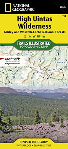
High Uintas Wilderness Map
• Waterproof • Tear-Resistant • Topographic Map
Explore the alpine vistas, glacier-formed lakes, and Utah's highest peaks with National Geographic's Trails Illustrated map of High Uintas Wilderness, Ashley and Wasatch-Cache National Forests. Expertly researched and created in partnership with local land management agencies, this map features key points of interest including Mirror Lake, Kings Peak, Sheep Creek Canyon Geological Area, and portions of the Yellowstone, Uinta, and Duchesne rivers.
With hundreds of miles of mapped trails, the High Uintas Wilderness map can guide you off the beaten path and back again. A handy chart notes each trailhead, the number of parking spaces at the trailhead, and the facilities available there including horse ramps, corrals, water, toilets, and developed campsites. Snowmobile and ATV trails, as well as four-wheel-drive and high clearance roads are clearly marked. The map base includes contour lines and elevations for summits, passes and many lakes. Helpful information about regulations and wilderness safety is included to help ensure your visit is safe and enjoyable.
Product details
Publisher : National Geographic Maps; 2020th edition (January 1, 2020)
Language : English
Map : 2 pages
ISBN-10 : 1566953715
ISBN-13 : 978-1566953719
Item Weight : 3.2 ounces
Dimensions : 4.1 x 0.4 x 8.9 inches
Best Sellers Rank: #57,611 in Books (See Top 100 in Books)
#56 in West Mountain United States Travel Books
#97 in Hiking & Camping Excursion Guides (Books)
#118 in Maps (Books)
Customer Reviews: 4.7
271 ratings
Amazon Price History
This is our record of Amazon price changes for High Uintas Wilderness Map (1566953715) since we began monitoring it.
| Price Type | Lowest Ever | Highest Ever | Current + | Average |
|---|---|---|---|---|
| Amazon | (Jul 04, 2026) | (Jul 04, 2026) | 0,00 € (Jul 04, 2026) |
0,00 €
Amazon Price
Jul 04, 2026 10:07 PM
Your Amazon Price Watches
We'll notify you when the price drops to your desired price.
Watch Price


Watch Price

Watch Price


