Watch Price
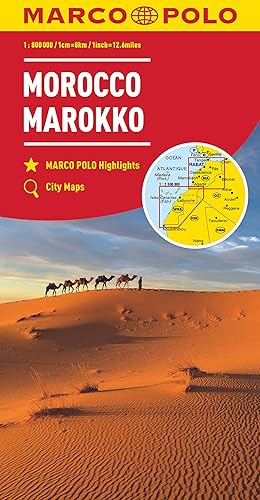
Algeria 1.800.000-1:2.000.000: Wegenkaart 1:800 000 / 1:2 000 000: 147 (Auto karte)
This detailed road map of Algeria is very suitable for planning and traveling around the country.
The road network is well represented, both the main roads, provincial and local roads. Road numbers are also clearly stated. Distances between places are marked on the map in kilometers, and gas stations are also marked in important places.
Shadow shows the relief and sometimes some points with the actual height. Province borders, national parks and reserves are easy to find. Symbols indicate the location of tourist sites, monuments, historically important places and viewpoints. In certain places you can find hotels and campsites, airports, train connections and ports.
Detalles del producto
Editorial : Freytag & Berndt; N.º 1 edición (16 marzo 2010)
Idioma : Inglés
Mapa : 1 páginas
ISBN-10 : 3707909662
ISBN-13 : 978-3707909661
Peso del producto : 131 g
Dimensiones : 13 x 1 x 25.6 cm
Clasificación en los más vendidos de Amazon: nº1.385 en Mapas y atlas
nº33.755 en Hogar, manualidades y estilos de vida (Libros)
nº89.718 en Libros en inglés
Opiniones de los clientes: 4,6
30 valoraciones
Amazon Price History
This is our record of Amazon price changes for Algeria 1.800.000-1:2.000.000: Wegenkaart 1:800 000 / 1:2 000 000: 147 (Auto karte) (3707909662) since we began monitoring it.
| Price Type | Lowest Ever | Highest Ever | Current + | Average |
|---|---|---|---|---|
| Amazon | (Jul 13, 2026) | (Jul 13, 2026) | 0,00 € (Jul 13, 2026) |
0,00 €
Amazon Price
Jul 13, 2026 04:16 AM
Your Amazon Price Watches
We'll notify you when the price drops to your desired price.
Watch Price


Watch Price


Watch Price