Watch Price
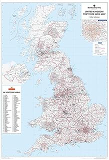
UK Postcode Wall Map - Laminated Large Wall Map - 120cm X 83cm - Clearly Shows Postcode, County And District Boundaries, Main Roads, Cities, Towns And Villages
Amazon Price History
This is our record of Amazon price changes for UK Postcode Wall Map - Laminated Large Wall Map - 120cm X 83cm - Clearly Shows Postcode, County And District Boundaries, Main Roads, Cities, Towns And Villages (B079T846LH) since we began monitoring it.
| Price Type | Lowest Ever | Highest Ever | Current + | Average |
|---|---|---|---|---|
| Amazon | (Jun 17, 2026) | (Jun 17, 2026) | 0,00 € (Jun 17, 2026) |
0,00 €
Amazon Price
Jun 17, 2026 03:59 PM
Your Amazon Price Watches
We'll notify you when the price drops to your desired price.
Watch Price


Watch Price